It is believed1 that the 1902 design served as an inspiration for the trail system, but the original trails were laid out by the CCC in the 1930s.
Likely there were adjustments when Cherry Lane and Brookside Drive were made to be continuous and the deer paddock was removed.
However, it is also likely that the county map from the 1980s(?) reflects the state of the trail system until 2007 or so when the SMC Trail Work Crew was formed by Don Schatz and Michael Feldman July 7th and 8th 2007 with the energy of the Mountain Bike Community.
This is from a followup email to the initial event:
Both personally and on behalf of the South Mountain Conservancy, I want to thank you for supporting the recent IMBA/Subaru Trail Care Crew visit at South Mountain. I do not believe the Reservation has ever seen such a positive outpouring of support from the mountain biking and hiking communities. Clearly, the considerable potential of these groups working together was demonstrated over the weekend of July 7th and July 8th. The fact that important decision makers and County officials were on hand Sunday to see the result of our efforts and participate in the trail building was really great.
If you are interested in the numbers, we had 20 participants at the Friday VIP reception, 60 students at the TCC Saturday classroom session, 45 trail workers on Saturday afternoon and over 40 trail workers on Sunday morning. The new trail is almost 7/10 of a mile long and took approximately 260 man hours to construct.
Sometime over the next several years, the leadership of the Trail Work Crew fell to Dennis Percher and John Verzani, who have carried the effort forward into 2024.
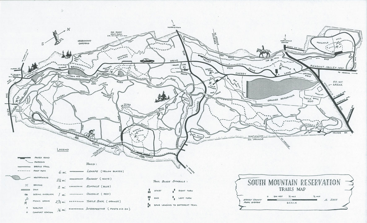
2.1 Primary hiking trails of the SMR
The SMR Trail Guide is a 60-page guide, describing the 50-plus miles of trails in the South Mountain Reservation with details of recommended hikes. What follows is a very brief description.
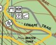
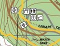
The Lenape Trail was established in 1982 and connects may parks and reservations through Essex County. Its longest section runs through the SMR from Locust Grove to Route 10 (south to north).
Lenape Trail
In addition to the Lenape trail, the following main trails are blazed
the white-blazed Rahway Trail (with part of it known as the Fairy Trail)
the red-blazed Swampy Trail
The blue-blazed Elmdale Trail
The red-blazed Oakdale Trail
The green- and white-blazed Mayapple loop
The orange-blazed Turtle Back Trail
The Mayapple and Turtle Back trails form loops; the Oakdale and Lenape trail; the Elmdale and Dogwood trail form a loop; and the Swampy, Summit, Openwood, Rahway form a loop within the five main areas, partitioned by South Orange Avenue, Northfield Avenue and Brookside Drive and Cherry Lane
There are other connector trails carrying the colors of both trails that combine these loops, among some other trails.
2.2 The carriage roads of the SMR
The reservation also has many carriage roads with the name of “trail.” The River Trail combined with the Reservoir Trail extends from Millburn to West Orange in the heart of the reservation; the West Ridge Trail runs along the western boundary; Crest Drive (paved) and the Longwood Trail extend along the Eastern boundary. In addition there are several carriage roads running east to west (Sunset Trail, Pingry Trail, Grassy Trail, Bear Lane, Balls Bluff Trail, Openwood Trail, Scout Trail, Hillspur Trail, Ravine Trail, CCC Trail, and North Trail.
Carriage roads have not been a priority for the Trail Work Crew, though some efforts at water management have been undertaken.
2.3 The main projects of the Trail Work Crew, 2007-2023
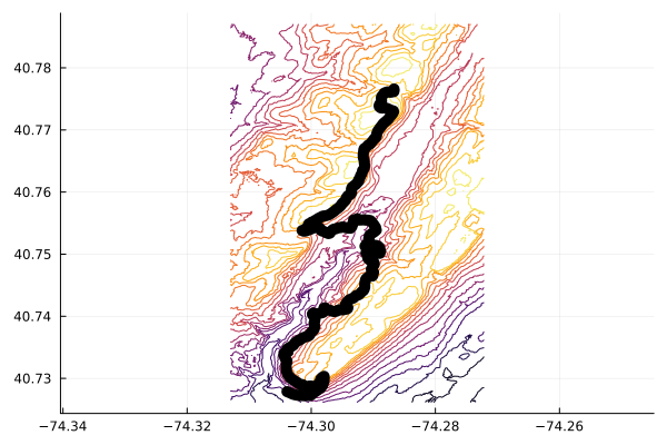
The Trail Work Crew has constructed or supervised the construction of numerous enhancements to the trail system of the SMR since 2007. The following chronicles the efforts by region and then chronologically. Any omissions are unintended and corrections are welcome. As possible, before and after images are provided from the county map and the SMC map or openstreetmap.org.
2.3.1 Elmdale region
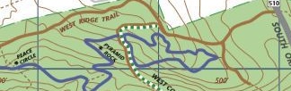
The Elmdale lollipop reroute was the second project undertaken by the Trail Work Crew and aimed to close down a portion of the Elmdale trail that was severely eroded. In the process it created a trail past pyramid rock.
Elmdale lollipop original
Elmdale lollipop reroute
Figure 2.1: Reroute of Elmdale “lollipop” avoiding washed out region and giving access to pyramid-shaped rock.
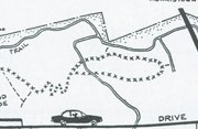
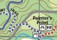
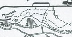
The Painter’s point picnic area had no natural entry to the trails west of Brookside Drive. A connector was an early project allowing trail access all the way to Old Short Hills Park.
Painter’s point before
Painter’s point connector
Figure 2.2: Create Painter’s point connection to elmdale trail creating painter’s point trail
A re-route of the high-low trail was done for safety reasons, as the old trail was dangerously close to a drop off.
Elmdale high-low before
Elmdale high-low after
Figure 2.3: Small reroute of high-low trail for safety reasons.
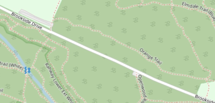
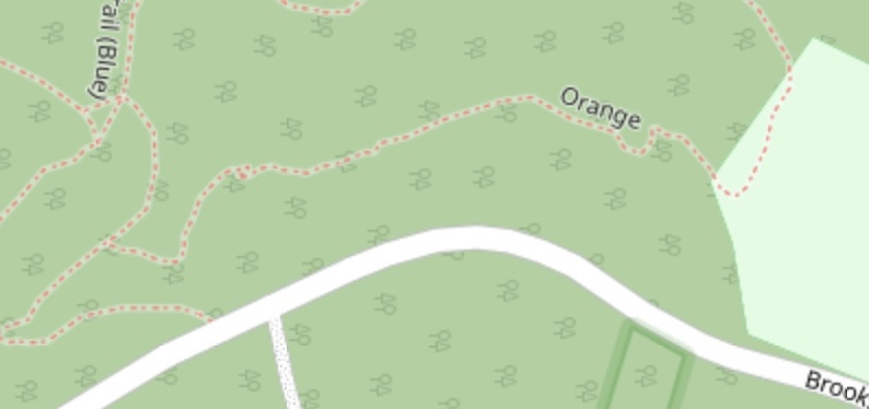
Dogwood hill has ample parking, but only had connections to the trail system to the west. The Dogwood hill connector headed north towards the sledding hill. It also provided access to two small parking areas on Brookside drive.
North of dogwood hill
North of dogwood hill
Figure 2.4: Addition of trail from dogwood hill north. Not seen, are spur trails to two small parking lots giving immediate access to the trail system.
South of the Dogwood Hill parking area a trail was added to connect with the Painter’s Point trail. This gave two layers of trails on that hill side in addition to the West Ridge Trail carriage road.
Figure 2.5: Trail connecting dogwood hill to the Painter’s Point trail.
2.3.2 Oakdale region
There is a planned re-route of a wet area of the Oakdale trail, but otherwise no substantial changes to the trail system have been undertaken by the Trail Work Crew.
2.3.3 Mayapple region
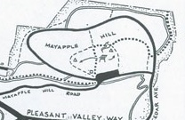
The Lenape trail runs through the Mayapple section and continues northward towards Route 10. An early project was to reroute the trail north of the picnic area. A more recent project was to add an alternate route for the Lenape connecting the Maypple loop to the carriage road that encircle the fields.
Lenape near Mayapple fields, before
Lenape near Mayapple fields, before
Figure 2.6: Reroutes for the Lenape trail through the Mayapple region
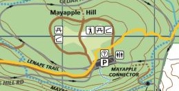
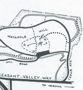
A large grant allowed the professional construction of several long trail segments. Included in that was the Mayapple Loop trail which added to the east side of the hill a stretch of trail affording a pleasant 2.5 mile loop. (The biking side trail further east was not designed or encouraged by the SMC.)
Mayapple loop before
Mayapple loop after
Figure 2.7: The Mayapple loop added a professionally built eastern portion.
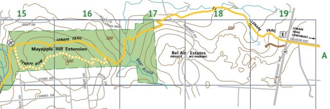
An 11-acre section of land north of the Mayapple was purchased in 2009. This is now accessible through the professionally built Mayapple extension trail which stretched the portion of the Lenape trail in the SMR further north. Further work, not shown on the map, was done to extend the Lenape to Route 10 in coordination with West Orange.
Mayapple extension
2.3.4 Turtle Back region
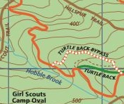
The first project of the Trail Work Crew was a reroute of the Upper Turtle Back trail. The old trail was a fall-line trail and suffered from erosion issues. This project was led by IMBA volunteers. Subsequent work was done to create “five-corners,” an intersection of the Turtle Back Bypass, the Turtle Back connector, and the upper Turtle Back trail.
Figure 2.8: Reroute of upper Turtle Back trail avoiding fall line trail
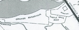
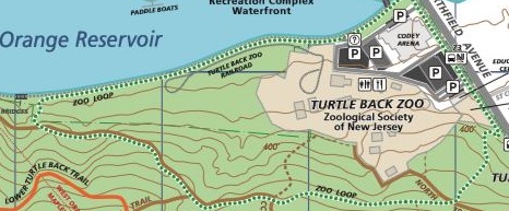
The zoo loop started as an effort to connect the Reservoir trail to the Orange Reservoir, at the time encircled by a fisherman’s trail. In discussion with the County to make a loop trail back towards the zoo, the paved Orange Reservoir trail was spawned. This has proven hugely popular. The zoo loop takes advantage of this paved trail, the reservoir trail, and a portion of trail constructed professionally that connected the CCC trail with Northfield Avenue. (The trail along the Turtle Back Zoo was planned to be shut down with a zoo expansion, though the trail is still walkable.) The portion of the zoo loop along Northfield Avenue goes by the original 0.11 acre purchase across St Cloud Avenue that began the SMR.
Zoo loop vefore
Zoo loop after
Figure 2.9: Creation of zoo loop, leveraging several new and old pieces.
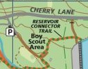
The Reservoir connector trail linked the popular loop around Orange Reservoir with parking near the Boy Scout Area.
Reservoir connector before
Reservoir connector after
Figure 2.10: New trail connecting the Orange reservoir trail with parking near the Boy Scout Area in Tulip Springs.
2.3.5 Main area of the reservation
The south-east quadrant of the reservation is easily the most used with its main access points being the Summit field/Crest Drive area, the Locust Grove parking area and the parking for the waterfall, in addition to a few others. We discuss efforts in different regions.
Hemlock falls region
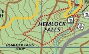
Hemlock falls remains a popular attraction. The rerouting of the Lenape Trail approach to Hemlock Falls from the south was an early project and the trail now gracefully enters following the contour of a natural amphitheater.
Hemlock Falls reroute before
Hemlock Falls reroute before
Figure 2.11: Reroute of Lenape Trail as it approaches Hemlock Falls from the south
The Hemlock falls loop was added following a suggestion by Dave Hogenauer. It provides a short loop incorporating the water fall.
Hemlock falls loop before
Hemlock falls loop after
Figure 2.12: Addition of Hemlock Falls loop
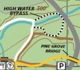
The Rahway trail west of the River trail near the Hemlock Falls parking area involved a stream crossing. This proved challenging when the water was high and a reroute was done. In addition a high-water bypass was created utilizing the bridge over the Rahway on South Orange Avenue.
Rahway bypass before
Rahway bypass after
Figure 2.13: Reroute of Rahway trail as it crosses Rahway river branch
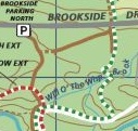
The Rahway to West Connector trail gave access to the Elmdale area from the Rahway trail by trail and not carriage road. It crosses over the intermittent Will O’ the Wisp brook
Rahway to West Connector before
Rahway to West Connector after
Figure 2.14: Addition of trail connecting the Rahway Trail to the West Connector
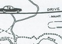
The popularity of Hemlock Falls on a nice weekend day leads to parking demand far in excess of the small parking area off South Orange Avenue. As suggested by Dave Berry, an overflow parking area was created by the County in its Maintenance area and a connecting trail was constructed by the Trail Work Crew.
Parking lot connector before
Parking lot connector after
Figure 2.15: Connector trail from overflow parking area for Hemlock Fall’s access
Summit field region
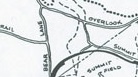
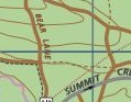
An extension of the Swampy trail to Summit trail was made. This allows a more natural south-to-north alternative to the Lenape trail.
Swampy trail to summit, before
Swampy trail to summit, after
Figure 2.16: Extension of Swampy Trail to Summit Trail
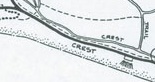
Washington Rock region
An old parking area dating to when Crest Drive allowed vehicular traffic was removed and in its stead a pavilion was put in. This was the impetus for moving the Lenape trail from along Crest Drive to the inside of the loop.
Lenape trail reroute, before
Lenape trail reroute, after
Figure 2.17: Reroute of Lenape trail near Washington Rock
The Hogenauer trail was reclaimed and blazed
Hogenauer trail, before
Hogenauer trail, after
Figure 2.18: Reclamation of Hogenaeur trail.
The small Swampy extension near Washington Rock allowed a red trail to connect the Locust Grove picnic area to the Turtle Back Rock picnic area.
Swampy extension near Washington Rock, before
Swampy extension near Washington Rock, after
Figure 2.19: Extension of swampy trail towards Locust Grove.
2.3.6 2023 onward
As of 2023, the trail system in the South Mountain Reservation is quite mature. Major new trails are unlikely. However, the current trail system – with over 50 miles of trails – needs maintenance.
The Trail Work Crew has organized several work days to improve trail sections, primarily along the Lenape trail near the Pingry Trail intersection and between Balls Bluff Trail and the Openwood Trail.
Beginning in 2023, Dave Berry has organized a SWAT team to fix trail issues. This group has spent productive time in the Turtle back area, on the Swampy trail, and on the Lenape trail.


